Stage 6 Gallegos de Argañan - Almeida

Santiago de CompostelaPadrónCaldas de ReisPontevedraRedondelaTuiRubiãesPonte de LimaBragaGuimarãesFelgueirasAmaranteMesão FrioLamegoMoimenta da BeiraSernancelheTrancosoPinhelAlmeidaGallegos de ArgañanCiudad RodrigoAlba de YeltesSan MuñozRobliza de CojosSalamanca

Gallegos de Argañan

Almeida

26 Km Distance
Medium Difficulty
6 Hours Duration
674 m Ameal 7,8 km 16,4 km 7,8 km SALAMANCA 805,3 m 882,8 m (altitudemáx.) Peñasolana 867 m 826 m El Encinar de la Rad 837 m (altitudemáx.) 6,5 km 4,1 km 8,4 km 819,3 m ROBLIZA DE COJOS 810 m Ermida de Santiago 819 m Estrada CV-107 12,4 km 9,6 km 4 km 839 m (altitudemáx.) 797 m Rio Yeltes 821 m Ribeira de Cabrillas SAN MUÑOZ 778 m 844 m (altitude máx.) 10,6 km 7,1 km 8,3 km 771 m Bocacara 727 m Pedro Toro ALBA DE YELTES 784,4 m 689 m (altitudemáx.) 12,4 km 3,6 km 621,5 m CIUDAD RODRIGO 596 m Ponte de Marialba 8,3 km 12,4 km 5,3 km 758,5 m (altitude máx.) Vale da Mula 689 m Aldea del Obispo 718 m Alameda de Gordón 663,3 m GALLEGOS DE ARGAÑAN 12,6 km 5,2 km 3,5 km 540 m Ponte do Rio Côa 739 m ALMEIDA 685 m Valverde 8,8 km 6,7 km 7,4 km 7,8 km 557 m Póvoa del Rei 633,6 m PINHEL 584 m Valbom 605 m Ponte do Abade 862 m TRANCOSO 6,4 km 9,1 km 11,9 km 650 m Benvende 3,5 km 9,5 km 3,8 km 2,7 km 592 m Arcozelo do Cabo 763 m SERNANCELHE 590 m Penso 564 m Vila da Ponte 839,9 m (altitude máx.) 14,6 km 10 km 5 km 451 m Ucanha 759 m Sarzedo 696,8 m MOIMENTA DA BEIRA 9,3 km 6,3 km 5,3 km 6,9 km 387 m Nostim Peso da Régua 529,5 m LAMEGO 258 m Valdigem 883,5 m (altitude máx.) 13,2 km 6 km 8,4 km 157 m Ovelhinha 316,7 m MESÃO FRIO 779 m Padrões 412,4 m (altitude máx.) 8,5 km 7 km 5 km 336 m Caramos 264 m Telões 95,9 m AMARANTE 425,2 m (altitude máx.) 12 km 5,8 km 315,7 m FELGUEIRAS 156 m Arco de Pombeiro 8,9 km 4 km 7,8 km 236 m Fraião 128 m Caldas das Taipas 194,5 m GUIMARÃES 436,7 m (altitude máx.) Falperra Vila de Prado 17 m Penegate 127 m Anais 238 m 274,8 m (altitude máx.) 7 km 12,1 km 8,7 km 7,6 km 190,5 m BRAGA 400,4 m (altitude máx.) 10 km 6 km 2,9 km 30 m Arcozelo Alto da Labruja 2,3 m PONTE DE LIMA 230,9 m (altitude máx.) 11 km 5,7 km 6,1 km 9,7 km 18 m Cruz de São Telmo 31 m O Porriño 83 m Mós 50,8 m TUI 275,3 m (altitude máx.) 11,2 km 2,6 km 4,7 km 34 m Valença 172 m Gontomil 200,7 m RUBIÃES 128,1 m (altitude máx.) 16 km 4,9 km 30 m Briallos 10,1 m PONTEVEDRA 153,3 m (altitude máx.) 5 km 7 km 8 km 31 m O Pobo 5 m Pontesampaio 13,5 m REDONDELA 164,9 m (altitudemáx.) 6,3 km 6,7 km 5,7 km 60 m São Miguel de Valga 147 m Carracedo 24,8 m CALDAS D’EL REIS 12,7 km 5,2 km 6,2 km 40 m A Escravitude 103 m Francos 265,7 m 9,9 m PADRÓN SANTIAGO DE COMPOSTELA

Introduction

The (in)visible border

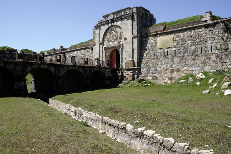
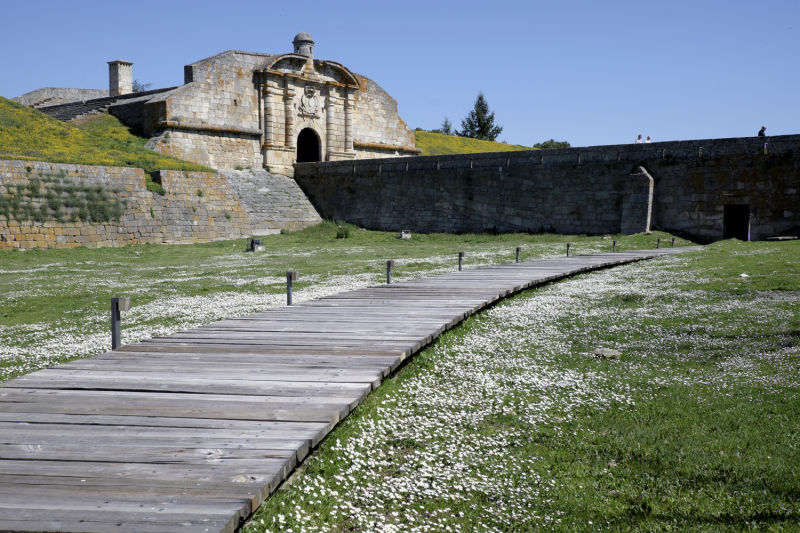
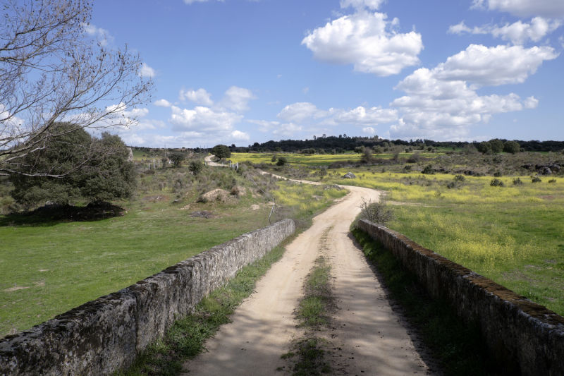
You can tell you are entering Portugal by the difference in the tar on the road after the bridge over the Tourões River. Beforehand, the passage through the fort of Our Lady of Conception already announces that the discreet valley of that river was a hard-fought border. There are other traces of this ancient war between Portugal and Spain: the castle of Gardón, written in the 17th century as Goardão, was the fortress that "kept" the Spanish border; on the Portuguese side, a stronghold was built at Vale da Mula, but the key to the defensive system of the restoration of Portuguese independence (1640) is 7 km ahead, in Almeida. This city was "hidden" behind mighty walls and, even today, the exact star of its perimeter, only truly visible from the air, represents a singular moment of the fight for the border.

If you start the journey at dawn, don't forget your reflective vest until Alameda de Gardón. The small patches of pine forests indicate that the landscape is starting to change. Further ahead, you have to ford the Dos Casas stream, which can be difficult during the rainy season. When you cross the border, the language of the people changes and so does the time.

Alternative dispute resolutionPrivacy policyCookies policyTerms and conditions 2024 In case of dispute click here here.