Stage 3 San Muñoz - Alba de Yeltes

Santiago de CompostelaPadrónCaldas de ReisPontevedraRedondelaTuiRubiãesPonte de LimaBragaGuimarãesFelgueirasAmaranteMesão FrioLamegoMoimenta da BeiraSernancelheTrancosoPinhelAlmeidaGallegos de ArgañanCiudad RodrigoAlba de YeltesSan MuñozRobliza de CojosSalamanca

San Muñoz

Alba de Yeltes

26 Km Distance
Low Difficulty
5 Hours Duration
674 m Ameal 7,8 km 16,4 km 7,8 km SALAMANCA 805,3 m 882,8 m (altitudemáx.) Peñasolana 867 m 826 m El Encinar de la Rad 837 m (altitudemáx.) 6,5 km 4,1 km 8,4 km 819,3 m ROBLIZA DE COJOS 810 m Ermida de Santiago 819 m Estrada CV-107 12,4 km 9,6 km 4 km 839 m (altitudemáx.) 797 m Rio Yeltes 821 m Ribeira de Cabrillas SAN MUÑOZ 778 m 844 m (altitude máx.) 10,6 km 7,1 km 8,3 km 771 m Bocacara 727 m Pedro Toro ALBA DE YELTES 784,4 m 689 m (altitudemáx.) 12,4 km 3,6 km 621,5 m CIUDAD RODRIGO 596 m Ponte de Marialba 8,3 km 12,4 km 5,3 km 758,5 m (altitude máx.) Vale da Mula 689 m Aldea del Obispo 718 m Alameda de Gordón 663,3 m GALLEGOS DE ARGAÑAN 12,6 km 5,2 km 3,5 km 540 m Ponte do Rio Côa 739 m ALMEIDA 685 m Valverde 8,8 km 6,7 km 7,4 km 7,8 km 557 m Póvoa del Rei 633,6 m PINHEL 584 m Valbom 605 m Ponte do Abade 862 m TRANCOSO 6,4 km 9,1 km 11,9 km 650 m Benvende 3,5 km 9,5 km 3,8 km 2,7 km 592 m Arcozelo do Cabo 763 m SERNANCELHE 590 m Penso 564 m Vila da Ponte 839,9 m (altitude máx.) 14,6 km 10 km 5 km 451 m Ucanha 759 m Sarzedo 696,8 m MOIMENTA DA BEIRA 9,3 km 6,3 km 5,3 km 6,9 km 387 m Nostim Peso da Régua 529,5 m LAMEGO 258 m Valdigem 883,5 m (altitude máx.) 13,2 km 6 km 8,4 km 157 m Ovelhinha 316,7 m MESÃO FRIO 779 m Padrões 412,4 m (altitude máx.) 8,5 km 7 km 5 km 336 m Caramos 264 m Telões 95,9 m AMARANTE 425,2 m (altitude máx.) 12 km 5,8 km 315,7 m FELGUEIRAS 156 m Arco de Pombeiro 8,9 km 4 km 7,8 km 236 m Fraião 128 m Caldas das Taipas 194,5 m GUIMARÃES 436,7 m (altitude máx.) Falperra Vila de Prado 17 m Penegate 127 m Anais 238 m 274,8 m (altitude máx.) 7 km 12,1 km 8,7 km 7,6 km 190,5 m BRAGA 400,4 m (altitude máx.) 10 km 6 km 2,9 km 30 m Arcozelo Alto da Labruja 2,3 m PONTE DE LIMA 230,9 m (altitude máx.) 11 km 5,7 km 6,1 km 9,7 km 18 m Cruz de São Telmo 31 m O Porriño 83 m Mós 50,8 m TUI 275,3 m (altitude máx.) 11,2 km 2,6 km 4,7 km 34 m Valença 172 m Gontomil 200,7 m RUBIÃES 128,1 m (altitude máx.) 16 km 4,9 km 30 m Briallos 10,1 m PONTEVEDRA 153,3 m (altitude máx.) 5 km 7 km 8 km 31 m O Pobo 5 m Pontesampaio 13,5 m REDONDELA 164,9 m (altitudemáx.) 6,3 km 6,7 km 5,7 km 60 m São Miguel de Valga 147 m Carracedo 24,8 m CALDAS D’EL REIS 12,7 km 5,2 km 6,2 km 40 m A Escravitude 103 m Francos 265,7 m 9,9 m PADRÓN SANTIAGO DE COMPOSTELA

Introduction

The endless landscape

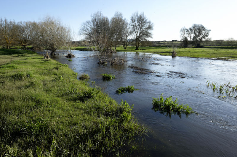
Today's stage is like the previous one, with the added difficulty that intermediate villages, where you can find support, are even further away from the way. Luís Quintales said this stage was the wildest of the Torres Way, so get ready for over 7 hours of walking without seeing a soul. Beyond the endless landscape, there are two obstacles to overcome: the Cabrillas stream and the Yeltes River. If you take the way during a rainy season, you are bound to have to walk in water to cross these courses. Should crossing be impossible, in the first case there is a bridge to the north-west, but the best thing is to turn back and head for the village of Cabrillas, where you will be able to recover your spirits for the second part of the stage. In the second case, it is best to walk about 1 km to the left, along the river, where you will find a bridge. Either of these options will add several kilometres to the journey, and could easily add up to 30km of walking.

Alternative dispute resolutionPrivacy policyCookies policyTerms and conditions 2024 In case of dispute click here here.